10th Hike: Mount Purgatory - Mangisi Traverse
The meet-up was scheduled for 9:00 pm in Cubao, and for the first time, I was late for the meet-up (I was the last participant to arrive). But according to Sir Jovi (Coordinator), my timing was just right because the driver of our van, which we were going to ride, had moved the departure time. I was joined in this event by Ken and Badet (whom I had previously hiked with in the Mascap Trilogy). At 10:50 pm, we set off for Benguet. The journey was long, so I managed to sleep, which was good since I was lacking sleep and needed some rest.
At 1:55 am, the group made a stopover to have an early breakfast. I also bought my pack lunch here for later when we would have lugaw. After a few minutes, we were back on the road. Upon reaching Baguio, we picked up another participant before continuing our journey. I had a hard time during the trip to the registration station, perhaps because our driver was driving too fast, but that's quite common with the drivers of vans used for hikes. Due to the zigzag road and the speed of the van, I felt extremely dizzy and nauseous during the journey, and I ended up vomiting on the side of the road when the van made a stopover - it was my first time!
Around 6:30 am, we reached the jump-off point. The whole group prepared, and of course, we took a group photo! At 6:45 am, we started our hike. The first part of the trail was paved, but immediately an assault trail greeted us. I slowed down my pace to avoid getting too tired. The weather was also cool, so it felt refreshing while ascending.
Not even half an hour had passed when we reached the first community, and everyone decided to take a rest due to the previous assault trail. Vehicles were passing by here, and I wondered where they were coming from. Some of us had a light breakfast while resting. After this, we started walking again. Just a few minutes into the walk, we reached the signpost of Mount Mangagew. After taking pictures, we resumed walking. Along the trail, we could see houses, but because we were in a high place, we had a clear view of the beautiful mountains of the Cordillera.
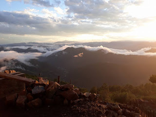
Not far from the entrance to the pathway, we saw the large signboard of Mount Pack, and at first, we all thought that was the summit of Mount Pack. Our guide immediately told us that it was not yet the summit of the second mountain we were going to climb. The trail became more wooded as we ascended Mount Pack. The path here became dense and wooded, and it was here that I first glimpsed the famous mossy forest of this traverse. Of course, we didn't miss the chance to marvel at what we saw and each of us took pictures.
There were parts of the trail that were a bit challenging, but they were manageable. Around 11:00 am, we reached the summit of Mount Pack. I sat down here because I was starting to feel tired. We also ate while resting and lined up to take pictures at the Mount Pack signboard. We didn't stay long and decided to continue on the trail after taking pictures because we were following our itinerary and, of course, we still had four more mountains to climb, with Mount Purgatory being our next destination.
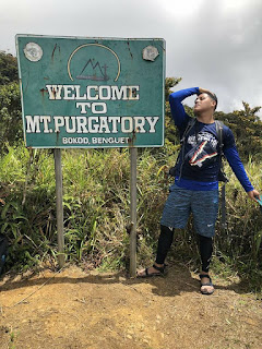
The trail to Mount Purgatory was gentle, almost descending, so we didn't have the chance to rest with my companions on the trail. The trail was still wooded here, but there were parts where you could catch a glimpse of the view. We continued walking, and after an hour of walking, the trail became more open. We spotted the signboard of Mount Purgatory, and as usual, we took pictures! We proceeded to the campsite at the summit where our group had lunch. The earlier group also had their lunch here. While eating, we could see the darkening sky, indicating rain was approaching. The guide also advised us not to linger too long to avoid being caught in the dark on the trail. We followed this advice as we only rested for 30 minutes and then continued on our way.
Our trail to Mount Bakian also took about an hour. There were houses here, and the signboard of Mount Bakian was just along the way. We didn't see any people in the area, but there were houses at the summit. We didn't stay long and went straight to Mount Tangbaw. It was drizzling at that time. According to the guide, the distance from Bakian to Tangbaw was less than an hour, which boosted our morale to continue on the trail (It wasn't really tiring because the weather was cool and refreshing).
In less than an hour (35 minutes), we reached the community where the signboard of Mount Tangbaw was very close by. The children welcomed us upon our arrival in their community. We gave them some of our extra trail foods even though they weren't asking, but you could feel the joy in their faces after being given a little food from us. We left our belongings at a store and went straight to the Tangbaw signboard for some pictures. We did it quickly because we were really in a hurry.
Some of us decided not to continue to the last peak and opted to stay at the store to watch over our belongings. We proceeded to Mount Kom-kompol. The rain started pouring, adding a challenge to the trail. After the uphill path, we entered the wooded part of the trail. The trail here was often steep. Our group also started to slow down due to the type of trail. There were times when Ken and I would stop on the trail for a quick break (probably just for 10 seconds). Some parts also became muddy because of the rain.
Our trail lasted for almost an hour, and we reached the view deck of Mount Kom-Kompol. We felt immense joy after reaching the view deck of the last mountain of our trek. Due to the rain, it was very cold there, and since I didn't have a poncho, I was shivering. According to our guide, there was still a section after the view deck where the actual summit of Kom-Kompol is located, but it was closed for trail maintenance. From the view deck, we could see Mount Pulag although it was a bit cloudy due to the rain. After a few minutes at the view deck, we decided to head back.
Upon returning to the store, the rain had stopped. We ate again here while resting. We started our descent from the mountain at 5:30 pm. Along the way (our guide said we took a shortcut), you would truly be amazed by the beauty of the mountains here in Benguet. There were many houses here, and sometimes I thought how envious I am of those who wake up to such a view every morning. But of course, people have different perspectives. I grew up in the city, so seeing this kind of view is probably new and refreshing for me, which you wouldn't see down below.
We were already in darkness when we reached the paved road below, and we were very fortunate because a passing truck didn't hesitate to give us a ride to the municipality (our group give thanks to the driver for giving us a ride).
The mountain experience in Benguet is truly unique because aside from the climate, the feeling it gives me is something I never feel in the city - the fresh air, the mossy forest, and of course, the simple way of life of the people living in the mountains.
ACTUAL ITINERARY:
2:30 AM Resume
5:10 AM ATA DENR Registration Office
6:40 AM ATA Jump-Off
6:45 AM Start of Trek
7:15 AM First Community / Rest
7:40 AM Resume
7:50 AM Mount Mangagew (1st)
9:00 AM Last water source
11:00 AM Mount Pack - Summit (2nd)
11:10 AM Resume
12:30 PM Mount Purgatory - Summit (3rd) / Lunch
1:00 PM Resume
2:00 PM Mount Bakian (4th)
2:10 PM Resume
2:45 PM Tindahan / Mount Tangbaw (5th)
2:55 PM Resume
3:58 PM Mount Kom-Kompol (6th)
4:45 PM ATA resumed at Tindahan
5:30 PM Start descent
6:45 PM Paveroad (waiting truck)
7:30 PM ATA Bokod Municipal Hall
10:30 PM ATA Baguio
April 22, 2018


Comments
Post a Comment